
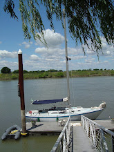
 Last night saw a pretty gnarly front roll through the Bay Area and pack some decent sustained winds as well as dump a bunch of water. Seeing as how I had just pulled one of my precious spreaders down and replaced it with a 2x4 cut to length and pretty much just wedged in there, I was fairly apprehensive when the first frontal wave washed through. Around 0300 the storm brought it. The way my particular marina is situated on this particular bay lends itself to pretty severe exposure to any sort of southerly weather. Winds blow up from the south bay, split around the city and then converge at the mouth of Richardson Bay, where they continue to be funneled through a bottleneck where my slip is. Combine this with a fetch all the way to San Jose and it makes for a wild ride. Winds sustained in the mid-thirties for a few hours, gusting to the forties, with 3-4 foot wind waves rolling headlong into my slip. Needless to say I didn't get much sleep last night. It did, however, make for a pretty good test of the temp spreaders. I think they'll hold out just fine, but the ride's not over!
I dropped off the spreader that I removed yesterday at North Bay Boatworks, and a fancy new one is being made as this is being typed! Looks like this project came along just in time as the spreader I removed was a little farther along the rot express than I had originally surmised. Hopefully it won't take too long for them to be made, and then they'll be stronger, lighter, prettier than they ever were!
Until then there are plenty more projects to attend to, and with the weather systems stacking up like they are I'm not likely to get very much done :-(
Here's the unfortunate weather synopsis for the next week:
.SYNOPSIS FOR THE CENTRAL CALIFORNIA COAST AND BAYS INCLUDING
 MONTEREY BAY...GULF OF THE FARALLONES...AND CORDELL BANK NATIONAL
 MARINE SANCTUARIES...

 A PERSISTENT LOW PRESSURE SYSTEM CENTERED JUST OFF OF THE
 CALIFORNIA OREGON BOARDER IS MAINTAINING SOUTHERLY WINDS ACROSS THE
 COASTAL WATERS. STRONGER SOUTHERLY WINDS WILL CONTINUE OVER THE
 SOUTHERN WATERS THROUGH LATE TONIGHT EARLY TOMORROW MORNING. SHOWERS
 AND THUNDERSTORMS WILL ALSO BE POSSIBLE TONIGHT IN RESPONSE TO
 THIS LOW PRESSURE SYSTEM. POST FRONTAL THUNDERSTORMS WILL ALSO BE
 POSSIBLE TOMORROW AS COLD AIR FILLS IN BEHIND THIS DEPARTING SYSTEM.
 WINDS WILL REMAIN SOUTHERLY AS THIS SYSTEM MOVES ONSHORE AND YET
 ANOTHER PACIFIC STORM SYSTEM APPROACHES THE COASTAL WATERS.

 $$
SAN FRANCISCO SAN PABLO SUISUN BAY AND THE WEST DELTA-
 252 PM PST MON FEB 16 2009

 SMALL CRAFT ADVISORY IN EFFECT THROUGH LATE TONIGHT


 TONIGHT
 S WINDS 15 TO 25 KT. SHOWERS AND SLIGHT CHANCE OF
 THUNDERSTORMS.
No comments:
Post a Comment